


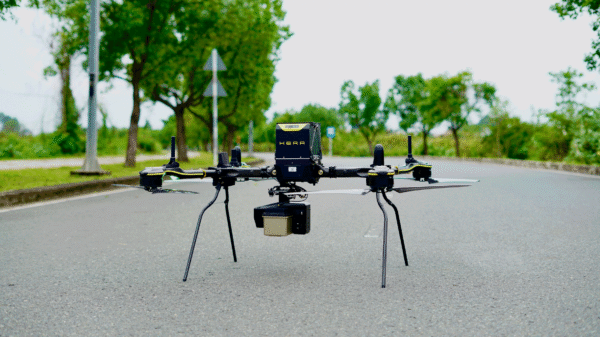
The companies say the integration gives customers a secure aerial mapping option that combines heavy-lift American-made drones with engineering-grade LiDAR.
Huntsville, Ala.-based GeoCue has announced that its TrueView LiDAR payloads are now compatible with drones from Real-Time Robotics Inc., a pairing the companies say expands NDAA-compliant drone LiDAR options for customers in surveying, defense, public safety and critical infrastructure.
The announcement extends a GeoCue product roadmap including the NDAA-compliant TrueView 641 unveiled at INTERGEO 2025 and the January partnership with JGC Geoinformation System that brought TrueView sensors and LP360 software to Greece and the Balkans.
NDAA-Compliant Drone LiDAR Systems
According to GeoCue, the integration centers on Real-Time Robotics’ HERA and VEGA platforms. The company says the HERA is a backpack-portable, NDAA-compliant tactical drone with a 30-pound payload capacity and up to 60 minutes of flight endurance, engineered for heavy-lift LiDAR, ISR and multi-sensor missions.
Real-Time Robotics says it designs and manufactures its airframes, avionics, motors, propellers, gimbals, flight controllers and smart battery systems in-house, and that its platforms can deploy in under a minute and operate in conditions that ground most tactical drones. According to the company, its aircraft carry up to four simultaneous payloads.
The complete Real-Time Robotics tactical uncrewed aircraft platforms have also received conditional approval and exemption from the FCC Covered List through the FCC’s Public Safety and Homeland Security Bureau, according to the release.
The LiDAR Payload
According to GeoCue, the HERA is paired with the TrueView 641, an NDAA-compliant aerial LiDAR sensor built for high-accuracy mapping and engineering-grade point cloud collection. The company says the TrueView portfolio pairs with LP360 software to provide a workflow spanning flight planning, data collection, processing, QA/QC, classification, visualization and deliverable generation.
Ethan Khanh Vo, chief operating officer of Real-Time Robotics, said in a statement that customers “need secure, mission-ready aerial systems that can support advanced sensor payloads and deliver reliable data in the field.” According to Vo, adding TrueView compatibility lets the company offer “a complete solution that brings together high-performance UAS technology, advanced LiDAR collection and the software tools needed to turn that data into actionable results.”
Vincent Legrand, vice president of global sales at GeoCue, said the partnership adds Real-Time Robotics platforms to GeoCue’s list of compatible NDAA-compliant drones. According to Legrand, the pairing gives customers “another excellent option for a secure, NDAA-compliant drone and LiDAR solution” for demanding aerial mapping projects.
More information is available at GeoCue.
Read more:

Ian McNabb is a journalist focusing on drone technology and lifestyle content at Dronelife. He is based between Boston and NH and, when not writing, enjoys hiking and Boston area sports.

