


Trying to figure out what your friend’s house looks like before you go for the first time? Google Street View almost certainly has a picture of it. Ever wanted to take a stroll through a distant city on a whim? Street View’s got you covered. How about a quick jaunt on Antarctica, or even space? Street View’s there, too.
Since launching in 2007, Google’s service for imaging the traversable parts of the world has been busy. Its coverage today boasts 12 million miles across 110 countries, which only gets more impressive once you realize that the company is taking new pictures of those miles all the time. And it’s not just roads: There are plenty of hard-to-access areas on the service, many of which cannot be reached by cars at all.
So how does Google do it? Yes, you’ve likely seen one of the brightly liveried Street View cars in your town at some point. But Street View collects data from all sorts of sources. It might take photos from satellites, planes, and even, if you’re willing, you. The real star of the show, though, is its proprietary camera system, which has evolved a lot over 20 years and has now reached the point where it can go on almost anything. In fact, it already has.
The camera that captured the world
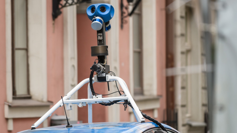
The Street View camera rig wasn’t always a technological triumph. The original model all the way back in 2007 was a 500-pound monstrosity that needed a forklift to actually get on the roof of the Chevrolet Astro van that became the service’s first vehicle. The camera’s been on a diet ever since, shaving hundreds of pounds off in the intervening decades.
The current model, introduced in 2022, is just a little lighter, weighing only 15 pounds. It therefore doesn’t require expensive and clunky mounting rigs that only work on a handful of cars. These days, anything with a roof rack can have a Street View camera slapped on it. Google then hires a legion of contract drivers to crisscross the world’s roads in the company’s vehicle fleet.
The cameras themselves feature seven 20-megapixel sensors and are wired into a bank of computers hogging the back seats. That stores all the information being collected; far more than just the images, the camera is collecting location data as well as the car’s speed and direction. These computers are eventually driven back to one of just three Street View hubs, one each in North America, Asia, and Europe.
Later processing stitches all of that together into a panorama of an exact spot in the world, and then stitches all those together into the navigable service we all use today. Lasers can even be added to the modular camera system to scan the area, which is how Google gets its 3D maps of a location.
Camera carriers
Any car with a roof rack gives Google a pretty wide set of options, but what if that’s still not enough? Well, turns out there are a lot of places cars just can’t go. Pedestrian promenades, great works of architecture, big campuses, or really rugged terrain — Google’s cameras needed some new carriers to get around a lot of the Earth. Basically, if it’s ever transported something before, it’s probably transported a Street View camera.
Camels for the harshest deserts. Boats for swampy waterways. Snowmobiles for, well, snowy bits. Scuba divers have photographed the seas. Human-powered trikes have gone where cars are forbidden to go. On the Faroe Islands, where sheep outnumber people, those sheep were put to work for Google. Obviously, on Mars, Google used an ATV (okay, not Mars, but Devon Island, the most Mars-like place on Earth). There’s even a push-cart trolley to get inside museums.
But to get to the really tough-to-reach places, you’ve got to go get some good old-fashioned humans. Hikers have schlepped Google’s backpack-mounted Trekker system to Machu Picchu, Antarctica, and even the interior of a volcano, among many other places. In fact, one guy went way, way out there — to space. Astronaut Thomas Pesquet took a custom rig to the International Space Station, which, yes, you can check out on Google Street View.
Beyond Google
All that is an expensive endeavor, which is why Google also ingests information from a variety of third-party sources, over a thousand in all. It’s also getting photography from satellites and aircraft. Local governments have a lot it can pull from, too.
But one of Street View’s biggest methods of getting new photography is you. All you have to do is buy a compatible camera, mount it to your vehicle of choice, take pictures on the move, and then upload it all to Street View Studio. Google will take it from there. This volunteer system grants Google updated images of all sorts of places it doesn’t cover on its own often if at all.
All combined, Google Street View covers most accessible areas in the world, really only missing out on the deepest deserts and tundras plus central Africa and most of eastern Russia. That would have seemed unthinkable in 2007, but Google, with the help of a nifty camera system and every vehicle under the sun, found a way to capture the world.