


China’s Yangtze River is the longest in Eurasia and the third-longest on the planet, flowing more than 6,000 kilometres from the Tibetan Plateau to the East China Sea. Its basin covers almost one-fifth of China’s land area and is home to hundreds of millions of people. More than 52,000 reservoirs have been built on the Yangtze and its tributaries since the 1950s to mitigate flooding, generate hydropower, stabilize water supplies and protect ecology.
There are a host of challenges in managing this massive basin to support the sometimes-contradictory goals of developing water sources sustainably and protecting ecosystems. Population growth, development and urbanization in the region are constantly increasing the demand for water, while escalating water pollution and pressures on biodiversity. Although the Yangtze River basin’s average annual precipitation has changed relatively little in the past two decades, shifts in rainfall patterns and landscape use have led to a rise in the frequency and severity of droughts and floods.
For example, the hydropower company China Yangtze Power, based in Beijing, has found that the average drought period is now two weeks longer than it was in 2000. In 2020, unusually heavy rains led to the Three Gorges Dam in Yichang having the highest inflow rates since its construction in 2003. Management of the water flow in that reservoir helped to mitigate flooding, but this inundation still affected 45 million people, with more than 140 people dead or missing and caused an estimated US$16.5 million in damages1.
AI to the rescue: how to enhance disaster early warnings with tech tools
A smarter, more robust system of tracking, modelling and managing water in this basin will help to alleviate such issues, resulting in enhanced operational safety and reduced costs. To this end, the Changjiang Water Resources Commission (CJW) is spearheading the Smart Yangtze River Project (see go.nature.com/4h51xzf), under the auspices of the Chinese Ministry of Water Resources. This project was proposed in 2022 and now has 597 million yuan (US$82 million) of dedicated government investment, for a basin-wide, full-coverage water-monitoring system, with a planned completion date of 2035 for the preliminary design. Many hydropower companies are also contributing hundreds of millions of yuan to the initiative.
At the heart of the project is a digital twin of the Yangtze River basin. This twin consists of an advanced 3D simulation of the whole region, using data on weather, water flow, ecology, sediment properties, topography, energy demand and more, to provide real-time modelling of projected flood routing, water engineering, scheduling, shipping, ecological impacts and other outcomes.
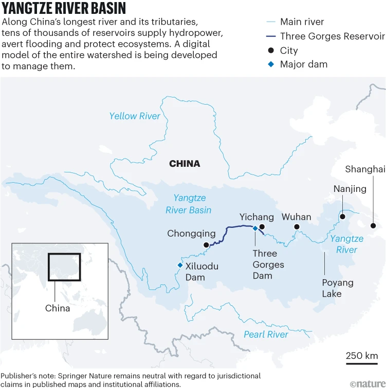
The intuitive interface provides a reliable assessment of the impact of resource-management decisions and watershed-protection actions on sustainable development and biodiversity health. It can be used for forecasting, early warning, emergency-system rehearsals and contingency planning. A first version of this digital twin already exists and is in use (see ‘Yangtze river basin’, and go.nature.com/3wvchj1), encompassing two supplementary watersheds (of the Han and Lishui rivers) and four dams (the Three Gorges, Danjiangkou, Jiangya and Zaoshi). This will be substantially improved and expanded with more data and modelling over the coming years.
Source: World Bank
Currently, nearly 2,700 water-level monitoring stations and more than 37,000 rainfall stations are collecting data in the Yangtze River basin. In April 2023, work began on new and existing hydrological-station networks in key areas such as the major tributaries of the Yangtze River, Dongting Lake and Poyang Lake, with enhanced monitoring methods including video and remote sensing. On completion, the Smart Yangtze River Project will also include hundreds of monitoring stations for water quality and groundwater levels, and tens of thousands of water intake points.
Much related work has been completed over the past five years — for example, China Yangtze Power now uses an intelligent decision-support system for reservoir-scheduling simulations and flood exercises. The Yangtze River Simulator, developed by the team of Xia Jun, a hydrologist at Wuhan University, China, is a tool for monitoring, simulation and analysis of flood control, power generation and biodiversity conservation2,3.
How to achieve safe water access for all: work with local communities
Although the use of digital twins has grown in the past decade for everything from industrial manufacturing to transportation, there are relatively few digital-twin representations used for intelligent watershed management. The Yangtze project might represent the largest and most ambitious such initiative yet. This huge endeavour presents substantial challenges in terms of enhancing existing data collection and management, as well as improving models and services.
Researchers have already amassed a wealth of data and experience. But the full potential of the Smart Yangtze River Project is still far from being realized. Funding shortages are an issue: numerous departments, companies and research institutions engaged in the project need to secure their own funding. More data need to be collected and digitized; data and model formats need to be standardized and shared across industry and academia.
Many companies have yet to engage in the project because of cost or technological constraints, or perhaps because they fear that it might affect their profits. Further collaboration should address these challenges, so that there is adequate guidance for managers’ decision-making.
Here, we recommend four steps that will help to ensure the success of the programme.
Unify data and model standards
A digital twin requires many types of data, taken at different time intervals and in various formats. For instance, a comprehensive and accurate rainfall and run-off model might require data on atmospheric temperature, humidity and cloud distribution from meteorological satellites and on surface vegetation coverage and land-use types from optical remote-sensing satellites. It might also need information on river morphology from drone-mounted cameras and terrain elevation from laser-based radar, or lidar. A digital twin requires enough data to drive high-resolution modelling but not so much that it creates transmission bottlenecks.
A lack of universal methods, standards and specifications makes it challenging to integrate data from multiple monitoring networks. Data are often fragmented across different entities and stored in diverse formats. For example, meteorological and run-off data are held by the Chinese Bureau of Hydrology; reservoir-operation data by hydropower companies; and water resource-management data by the CJW. Inside the government, multiple data formats are used: the water-conservancy department utilizes HDF, the environmental-protection department uses CSV, the meteorological-department relies on NetCDF and the power department utilizes COMTRADE.

Digital twins, such as this one of Zaoshi Dam, can help with real-time water management.Credit: Dr. Xiaopeng Wang
Not all of the desired information is even digitized. Information about electricity demand, power market data, power-line restrictions and emergency information, for example, is still sometimes recorded and analysed without the use of computers. Existing reservoir dispatching regulations, projects and plans are typically documented in hand-written form rather than digitally.
It is also important to develop standards for the models used to process all these data, to ensure that they are versatile, reusable and interoperable. It is essential to create a common design and development platform for the Smart Yangtze River Project system, enabling all models to operate seamlessly. The project is creating unified data and model standards. Nevertheless, numerous areas remain inadequately compatible.
There are few global examples that show how to develop digital twins in a robust way with good standards — in general, the concept of digital twinning is more advanced in industrial manufacturing than in river management. One such example is the virtual shared workspace established by US aircraft manufacturer Boeing to facilitate collaboration among its corporate partners. The European Digital Twin Ocean project (see go.nature.com/3cdab5p) has established a data-governance framework to set standards for data and models across a wide swathe of content, including satellite observation data, ocean-model outputs, in situ measurements and data from historical, industrial and citizen-science sources.
Share data and models
Currently, the Yangtze digital-twin platform is hosted by the Yangtze River Commission and several companies’ internal networks, and it is not fully accessible to scientists and others who work around the basin. The interaction between industry and academia is minimal, hindered by obstacles in accessing information and resources, often attributed to commercial confidentiality. One issue lies in data ownership. Regional water-management departments and companies are generally reluctant to share commercially sensitive information. Likewise, hydropower companies can find it hard to obtain power dispatch data from power-grid companies.