

By DRONELIFE Features Editor Jim Magill
(Part of a series on the drone community’s response to natural disasters)
Hurricane Helene, the massive and deadly storm that tore through a large swath of the U.S. Southeast in late September, triggered a tremendous response from the drone-flying community, as individual operators and private companies deployed their UAVs to transport much needed supplies and medicines, assess the damage wrought by flooded streams and rivers and even help locate the remains of people who tragically perished in the devastating floods.
Drones come to the rescue after flooding in North Carolina

Despite all predictions to the contrary, western North Carolina was especially hard-hit by Hurricane Helene, whichafter making landfall as a Category 4 hurricane in the Big Bend region of Florida on September 27 tore a path of destruction through Georgia and roared through the southern Appalachian Mountain region as a tropical storm, dumping record-breaking amounts of rainfall across the region.
The historic rainfall caused massive flooding as several rivers and creeks in the region overflowed and inundated a number of communities. Mudslides and landslides destroyed highway infrastructure, leaving many areas cut off from power, transportation and communications. The storm and its aftereffects resulted in an estimated 96 deaths in North Carolina, and Gov. Roy Cooper’s administration estimated the damages would total at least $53 billion.
Aaron Schradin, the cofounder and CEO of software company Virtual Sandtable, said the flooding presented unique challenges to local disaster responders. The company volunteered its services to provide drone-based mapping and photogrammetry services to aid emergency workers in the area around Spruce Pines, N.C., in the wake of the storm.
The scale of the destruction presented a unique set of problems for local emergency management organizations, Schradin said. Most North Carolina-based first responders with hurricane recovery experience had obtained it through providing aid to other regions, such as Florida or New Orleans, not in their own backyard. “They’re not typically handling such disaster responses at home,” he said.
Yet, in the immediate aftermath of the storm, these community-based workers rose to the challenge, coordinating relief efforts and marshalling the services of volunteer helpers, like Virtual Sandtable and other drone-based groups, that came in from all over the country, before federal relief efforts were able to get well under way.
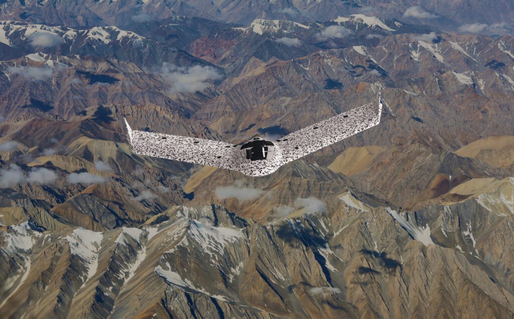
Schradin and his team deployed eBee Tac mapping drones and other UAVs and related equipment, on loan from AgEagle Aerial Systems, to conduct aerial surveys of the flood-devastated region. They were among the first group of volunteer responders to arrive in the area.
“Some of our team was there before the rain stopped. They are residents of North Carolina. One individual, Brian Clark, was there setting up camp and figuring out how to get supplies in and out before the rain stopped and the waters went down,” he said.
The volunteer responders set up the base position at the area’s Bethel Missionary Baptist Church, which was on higher ground. They initially used four of Virtual Sandtable’s Robinson R44 light helicopters to ferry supplies to the base and to conduct initial searched for survivors of the flood.
“We would look for survivors, people who would wave us down, we would land, try to get them internet, and then understand what kind of resources they needed,” Schradin said. “And the heli would come back full of resources, from diapers, to insulin, to oxygen, to whatever type of medicines and foods for that community — that was, at that point in time, unreachable — was in need of.”
Schradin said he would then load the eBees into one of the helicopters and fly to a designated search area where he would deploy the drones to fly quadrant patterns covering an area of between four and five thousand acres.
“And then they would take me to a new location. The equipment that I typically had was the eBee, a backpack with various spare parts, a laptop that would communicate through the WIFI transmitter for the bird and then a couple of radios and batteries and of course a Starlink.”
Using a hookup to the Starlink satellite internet network, Schradin’s team was able to communicate with local first responders on the ground, who could in turn communicate with the people in the affected communities, to let them know that airborne help was on the way.
The eBee Tac drone technology allowed the team to conduct search patterns covering wide areas in a relatively short period of time. “Even though the flight paths were overlapping, they would offset in altitude and miss each other so that you could do twice the area half the time. And time was really important for us in that scenario,” he said.
With the use of PingUSB equipment, the team was able to monitor the ADS-B feeds from manned aircraft that were operating in the disaster area, including some helicopters that were flying at very low altitudes in the airspace shared by the drones. “You might not imagine this, but there’s quite a bit of traffic for rescue operations,” Schradin said.
The Ping ADS-B provided direct communication with the AgEagle drones’ SenseFly software to notify the pilots of the drones and to deconflict the airspace. “So, if an ADS-B-emitting aircraft is in the space, the drones can respond to it properly,” he said.
When the visual data from the drone missions were analyzed, first responders on the ground were able to view the extent of the damage and decide where they needed to deploy their resources most effectively. The images tell the harrowing story of how the floodwaters moved homes off their foundations, created huge debris fields and changed the course of streams and the very landscape of the area.
“We would take those images and we created a model. And from the model, we could share that information and generate crowdsourced response,” Schradin said. Sadly, thermal data collected from overflights of the debris fields could also indicate the possible presence of remains of people who had perished in the floods, alerting the responders on the ground as to where to deploy their specially trained search dogs.
Every data point in the software application contains latitude and longitude coordinates, helping rescue and recovery workers pinpoint the locations of where they needed to send their resources.
“Volunteer groups that sometimes show up for these events can often be untasked and be twiddling their thumbs waiting for tasking. And this is a very eloquent, very quick way to provide for them some tasking orders,” Schradin said.
Bill Irby, CEO of AgEagle, said he was proud to have been able to assist in the hurricane recovery through the loan of UAVs and related materials to Virtual Sandtable. “We’re just really excited to be able to be used for these types of missions. There’s nothing better than providing real-world help to a person in need.”
He noted that the company’s eBee TAC aircraft are particularly well-suited to the type of search and recovery missions used in disaster response.
“First of all, from a sensor perspective, we do real-time video, normal RGB (red, green & blue) video, as well as thermal detection. So, either day or night, we can fly missions and locate missing people or just view areas that were impacted in different ways from the storms,” he said.
In addition, because they are fixed-wing aircraft, the eBee TACs have a much longer flight endurance time than quadcopter drones, 90 minutes on a single battery charge versus 45 to 50 minutes for multi-copter drones. “And that’s really important because the amount of area that you can cover in the same amount of time is much greater than what you can do with a quadcopter,” Irby said.
He said he foresees a much greater reliance on UAV systems for disaster response in the future. “It’s very easy to utilize these systems,” he said. “Because they’re much less expensive than some typical aircraft is another reason that you’re going to find a lot more use of them for these types of disasters.”
Read more:
 Jim Magill is a Houston-based writer with almost a quarter-century of experience covering technical and economic developments in the oil and gas industry. After retiring in December 2019 as a senior editor with S&P Global Platts, Jim began writing about emerging technologies, such as artificial intelligence, robots and drones, and the ways in which they’re contributing to our society. In addition to DroneLife, Jim is a contributor to Forbes.com and his work has appeared in the Houston Chronicle, U.S. News & World Report, and Unmanned Systems, a publication of the Association for Unmanned Vehicle Systems International.
Miriam McNabb is the Editor-in-Chief of DRONELIFE and CEO of JobForDrones, a professional drone services marketplace, and a fascinated observer of the emerging drone industry and the regulatory environment for drones. Miriam has penned over 3,000 articles focused on the commercial drone space and is an international speaker and recognized figure in the industry. Miriam has a degree from the University of Chicago and over 20 years of experience in high tech sales and marketing for new technologies.
For drone industry consulting or writing, Email Miriam.
TWITTER:@spaldingbarker
Subscribe to DroneLife here.