


A data set nearly doubles the known length of roads used during the Roman Empire. Credit: Itiner-e, Artas Media, MINERVA
A high-resolution digital map allows people to plan their routes along the ancient roads of the Roman Empire. Combining historical records with modern mapping techniques, researchers mapped hundreds of thousands of kilometres of roads. The findings nearly double the known length of Roman roads.
The data set was published in Scientific Data on 6 November alongside an online platform called Itiner-e, which study co-author Tom Brughmans calls a “Google Maps for Roman roads”1.
“It’s a growing resource for a community to keep on adding information to to ensure that this remains the best representation of our knowledge of where all the roads in the Roman Empire were,” says Brughmans, an archaeologist at Aarhus University in Denmark.
Brughmans hopes the data set will “revolutionize our understanding of how people, ideas and infectious diseases” spread 2,000 years ago. “Such insights can be used to better understand the challenges we face today,” he adds.
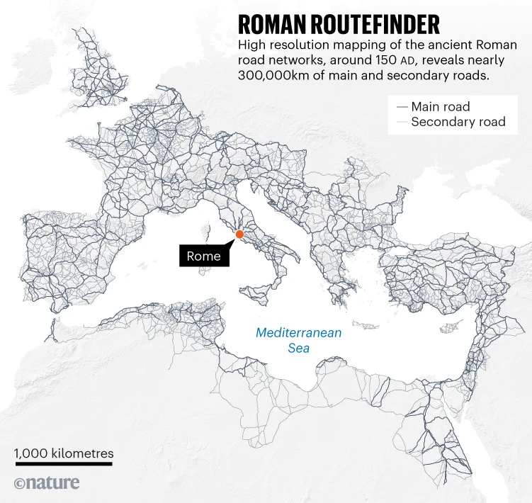
Source: itiner-e.orgRoman Routefinder: Map showing high resolution mapping of the ancient Roman road networks, around 150 AD, revealing nearly 300,000km of main and secondary roads.
Roman Google Maps
Previous attempts to map the road networks of the Roman Empire had created incomplete data sets with low spatial resolution, and estimations for road locations rather than evidence-based reconstructions.
“Although the roads are one of the best-known aspects of Roman history, it’s surprising how many details about them we still don’t know,” says Catherine Fletcher, a historian at Manchester Metropolitan University in the United Kingdom.
The researchers first identified Roman roads from previous studies, including atlases, surveys, historical sources, archaeological sources and existing milestones. They then compared this information to modern and historical aerial photographs, topographical maps and satellite imagery. The team digitized each road section with a high spatial resolution, then combined the sections into Itiner-e.
The map includes nearly 300,000 kilometres of roads existing in around ad 150, when the empire was at its maximum territorial extent.
Higher spatial analysis allowed the researchers to map 200,000 kilometres of secondary roads. By combining different sources, the researchers could map winding roads crossing difficult terrain with more accuracy, thereby improving on previous estimates based on unrealistic direct lines over, for example, mountain passes.
The data set also reveals that the locations of only 3% of Roman roads are known with certainty. A further 7% are considered hypothetical, because they have been identified but not precisely located or verified across sources. The remaining roads are conjectured and based on fewer documented sources.
“This was a huge surprise and a sobering realization,” says Brughmans. But “that 3% certainty figure isn’t a failure; it’s a ‘call to action’ that gives us a precise confidence map of what we don’t know and where to look next”.