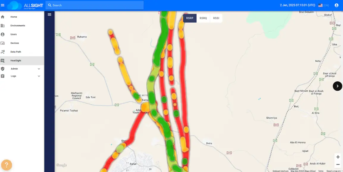
· Cellular signal mapping tool provides data on high altitude network coverage for more effective and safer drone flights
· Provides time-aggregated and altitude-based heatmaps
· Available to Elsight’s AllSight management platform customers
ASX-listed Elsight, the market leader in connectivity for unmanned and autonomous systems, has launched HeatSight, a revolutionary signal strength mapping tool which provides reliable data on cellular coverage for more effective and safer drone flight planning.
HeatSight, which is available to Elsight’s AllSight management platform customers, enables cellular coverage mapping by providing time-aggregated and altitude-based heatmaps, revealing where and when coverage thrives and where it falters across four dimensions (longitude, latitude, altitude, and time).
Just as the traffic app Waze helps motorists avoid congestion, HeatSight can help UAV operators detect where cellular signal coverage is stronger for safer and more reliable flights.
Whether a mission involves observation, delivery or inspection, reliable connectivity is pivotal in ensuring continuous and reliable Beyond the Visual Line of Sight (BVLOS) communication which is critical for flight control, navigation, and uninterrupted data transmission.
“HeatSight reveals the intricate landscape of cellular coverage by capturing the actual connectivity experience from a drone’s perspective,’’ Elsight Chief Executive Officer Yoav Amitai said.
“Just like Waze enables motorists to find the best routes to their destinations, HeatSight enables effective route planning for UAV operators for BVLOS missions.’’
Using HeatSight, drone operators may discover that certain areas experience signal congestion during specific periods which would enable them to adjust mission times for uninterrupted connectivity.
HeatSight can also help operators understand how weather conditions affect connectivity in specific locations and use historical data from storm and non-storm scenarios to prepare for real-time challenges without having to rely solely on live data streams.
“This actionable intelligence can make the difference between mission success and failure,’’ Mr Amitai said.
HeatSight leverages Elsight’s Beyond the Visual Line Of Sight (BVLOS) technology using its Halo complete connectivity system which records multiple RF (Radio Frequency) parameters during every flight for each cellular network and across different altitudes and times.
The data is uploaded to Elsight’s AllSight Cloud Management platform, where it is aggregated over time to provide a continuously evolving picture of the network coverage landscape from a UAV’s standpoint.
“HeatSight reveals the intricate landscape of cellular coverage by capturing the actual connectivity experience from a UAV perspective,’’ Elsight Chief Executive Yoav Amitai said.
“By producing a detailed and accurate data history of cellular coverage, HeatSight could simply regulatory mandates dictating that UAV flights maintain ‘well-connected’ paths.’’
Elsight (ASX: ELS) delivers connection confidence with proprietary aggregated bonding connectivity to deliver reliable, secure, high bandwidth communications – even in the most challenging areas for stationary, portable, or activity mobile situational systems manufacturers, operators, and integrators for both commercial and defence markets. www.elsight.com
Related
Discover more from sUAS News
Subscribe to get the latest posts sent to your email.


